Pennsylvania Railroad
Glossary
PRR
Yards and Shops - Note that none of these yards or shops remain in
2007 having been replaced by the Buckeye Yard on Columbus' west side or
are no
longer needed. There was, of course, much change to the yards in
Columbus over the years as traffic expanded and railroads were consolidated.
The descriptions that follow try to describe the landscape in 1950.
The car capacities shown for each yard have not been confirmed.
CA&C Yard
- Located near the PRR Yard B Classification Yard likely used for
CA&C traffic to Akron and Cleveland. Capacity 657 cars.
---------------------------------------------------------------------------------------------
Chase Avenue Yard
- map -
This CA&C yard is a small banana shaped yard located on the joint
CA&C/N&W main just north and west of the St. Clair Avenue roundhouse.
In the 1950's it was used to store out-of-service steam locomotives.
---------------------------------------------------------------------------------------------
Davis Avenue Yard
- A small yard on the PRR's Miami line west of Scioto Tower on the west side
of Columbus. Used to interchange traffic with the C&O.
---------------------------------------------------------------------------------------------
Grandview Yard
- Located on the Piqua line south of Goodale Avenue between
Grandview Avenue on the west and the Olentangy River on the east. It
was a hump yard with capacity for 301 cars on the Grandview Receiving side
and 367 cars on the Grandview Classification side. It was used for
interchanging coal loads from the C&O destined for the Sandusky Branch or
the Chicago direction on the Piqua line. It was also used as an
overflow yard for PRR Yard A and Yard B. In addition it handled
stone cars from the Marble Cliff Quarry located next to the Grandview
Yard.
---------------------------------------------------------------------------------------------
Joint Yard -
Four tracks the PRR leased from the N&W in their Joyce Avenue Yard.
located in the southwest corner of the Joyce Avenue Yard they were used
for the interchange of coal trains destined for the Chicago area via the
Piqua line.
---------------------------------------------------------------------------------------------
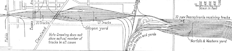
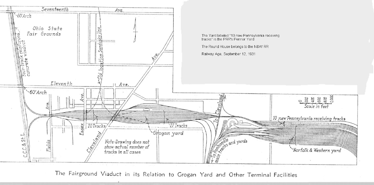
Grogan Yard -
map - Grogan Yard was the PRR yard
used for trains to and from Sandusky on the Sandusky branch. Trains
were also made up for Crestline, Toledo, and Cleveland. It was
oriented east -west and sat south of the Ohio State Fairgrounds and west
of the N&W's Joyce Avenue Yard. In 1930 it was enlarged from 1,010 to
2,105 car capacity. Trains on leaving Grogan Yard encountered a
sweeping turn to the north taking the line along the western boundary of the
Fairgrounds.
Grogan Yard was named for one of the streets that dead-ended into the yard from
the north.
---------------------------------------------------------------------------------------------
Joyce Avenue
Roundhouse and Twentieth Street Shops
- map - The roundhouse and shops were
located on Columbus' eastside east of Joyce Avenue and west of Taylor
Street. They were bordered on the north by Gibbard Avenue.
This was the largest PRR shops west of Altoona, Pa and handled heavy
servicing for Pennsy West locomotives. The facilities also include a
tender and car shop. At one time they employed 7600 workers making
the shops the largest employer in Columbus. Conversion to diesel
locomotives ended the need for the Columbus shops.
---------------------------------------------------------------------------------------------
Pennor Yard
- map - Pennor Yard was a ten track PRR
yard that was on the north side of the
Norfolk and Western Railroad's Joyce Avenue Yard and east of the
CA&C main line. The west end of the yard
converged into two tracks that crossed the CA&C's track and expanded into
Grogan Yard. The east end (or actually
south end as the yard was in an "L" shape) of the yard connected to the
N&W as part of the Joyce Avenue Yard. It was used to receive trains,
mostly coal trains, from the N&W destined for the PRR's Sandusky Branch.
The "Pen" in Pennor stood for the Pennsylvania and the "nor" for the Norfolk and
Western.
Pennor Yard was built in 1930 as an expansion of a smaller Gorgan
receiving yard that was part of a number of improvements for handling coal
traffic through Columbus. These improvements included the expansion
of the N&W Joyce Avenue Yard and elimination of grade crossings on the N&W
through Columbus.
---------------------------------------------------------------------------------------------
Spruce Street Yard
- The Spruce Street passenger engine terminal and coach yard was placed in
service in September 1924. It moved passenger locomotive servicing
from the more distant St. Clair
Avenue engine terminal. It included a
32-stall roundhouse, a coach yard for both PRR coaches and Pullman Company
cars as well as a dining car commissary. N&W passenger cars were
also serviced at this yard. It was located just west of
the Columbus Union Station.
---------------------------------------------------------------------------------------------
PRR Stock Yard
- Located on the south side of the main line west of James Road.
Used for receiving cattle and hogs.
---------------------------------------------------------------------------------------------
PRR Yard A
- Yard A was divided into two
parts, an eastbound receiving yard (map
see "E.B. REC Yard") of 323 car capacity and an eastbound classification
yard (map see "E.B. CLASS Yard") of 1088
car capacity. Yard A Receiving was located on the east side of
Columbus, south of the 20th Street Shops between St. Clair Avenue and
Taylor Avenue. The Yard A Classification, a hump yard extended from
the east end of the receiving yard to Nelson Road. Trains from
Logansport, Indianapolis and Cincinnati destined for Pitcairn and Conway
yards were worked from yard A. Yard A also had an interchange with
the N&W at Taylor Avenue.
---------------------------------------------------------------------------------------------
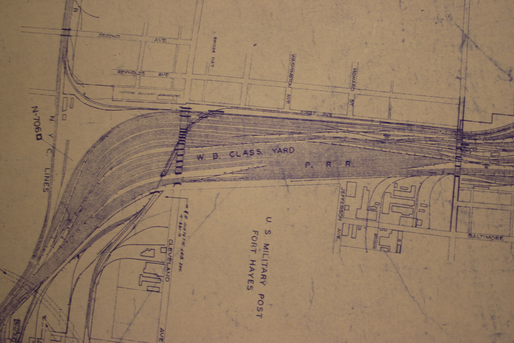
PRR Yard B
- Yard B was also divided into two
parts, the westbound receiving yard (map
see "W.B. REC Yard") of 1063 car capacity and the westbound classification (map
see "W.B. CLASS Yard"), a hump yard of 1044 car capacity. Yard B Receiving
was located on the east side of Columbus between the 20th Street shops and
Yard A Receiving. The Yard B classification yard was located just
north of Fort Hayes, west of St. Clair Avenue, it extended west under
Cleveland Avenue where it curved to the south toward Columbus Union
Station. Yard B was used to work trains out of the Pitcairn and
Conway yards destined for Logansport, Chicago, St. Louis, and Cincinnati.
It may have had an interchange at one time with the N&W at Reed Avenue.
---------------------------------------------------------------------------------------------
PRR
Yard C -
The downtown freight house and a small yard located at the
northeast corner of Naghten and Fourth Streets.
---------------------------------------------------------------------------------------------
Miami Yard - Team tracks and
a less then
car load (LCL) freight facility located on the northeast corner of Naghten and High
Streets.
---------------------------------------------------------------------------------------------
Milo Yard -
Located near the Yard B Classification Yard possibly used for local
dispatch to downtown Columbus. It was possibly absorbed into Yard B by
1950. Capacity 232 cars.
---------------------------------------------------------------------------------------------
The Pennsylvania Railroad and its origins in Columbus - PRR -
Map - The PRR leased the PCC&St.L in 1921
for 999 years.
Pittsburgh
Cincinnati & St. Louis Railroad - PC&St.L (1869) - Subsidiary
of the Pennsylvania Company formed to lease rail lines west of Pittsburgh
for the PRR.
Chicago St.
Louis and Pittsburgh Railway Company - CSt.&P (1884) -
Reorganization of the PC&St.L
to satisfy court orders.
Pittsburgh
Cincinnati Chicago and St. Louis Railway Company - PCC&St.L (1890) New
"Lines West" operator of leased lines of the PRR.
Pittsburgh,
Cincinnati, Chicago & St. Louis Railroad Company -
PCC&St.L
(1916) - The PCC&St.L was the final
collection of the various railroads that included the
Little Miami
to Cincinnati, the Piqua
Line to Indianapolis,
St. Louis and Chicago and the
Pan Handle route to
Pittsburgh that the Pennsylvania Railroad, in the late 19th century took
under long term leases. This Company held leases in Ohio,
Indiana and Illinois and would also be know as the Pan Handle.
Railroads that
made up the PCC&St.L -
Little Miami -
The railroad that would be nicknamed the "Little Miami" entered Columbus
in 1850 from the west, north of and parallel to West Broad, crossing the Scioto
River through a covered bridge, then in front of the Ohio Penitentiary, and
to its depot at North High and Naghten Streets.
Columbus & Xenia Railroad
- C&X -
(1850) - The first railroad built in Columbus. It was 55 miles long
running from Columbus to Xenia Through London and West Jefferson.
Little Miami Railroad
(1853) - The Little Miami Railroad between Cincinnati and Xenia was
already in existence when the C&X reached Xenia allowing rail travel from
Columbus to Cincinnati. In 1853 the C&X and LM started operating as
one railroad and was referred to as the "Little Miami". In 1868 the
LM leased the C&X which in turn was leased in 1869 PC&St.L
Piqua Line -
The "Piqua line" passed through Piqua, Urbana, Milford Center, Plain City,
and Hilliards, entering Columbus through Marble Cliff and the southern
edge of Grandview Heights, crossing the Olentangy River, south of Goodale
Street, and extending eastward across Dennison Avenue, north of the
Ohio Penitentiary into Columbus Union Depot.
Columbus Piqua &
Indiana Railroad - CP&I - (1853) - the CP&I reached Piqua in 1853 and
Union City on the Ohio - Indiana border in 1856. The line eventually
extended through Logansport, IN to Chicago.
Columbus &
Indianapolis Railroad - C&I - The C&I acquired the CP&I when the
latter ran into financial problems. It was combined with another
line from Bradford Junction, OH to Richmond, IN and on to Indianapolis.
In 1869 the C&I was leased to the PC&St.L.
Pan Handle Route - The "Pan Handle Route" is the name
originally applied
to the PRR's Columbus - Pittsburgh line. Later it would apply to the
entire PCC&St.L. It gets its name from the
small northern area of West Virginia which reminds one of a cooking pan handle.
The route entered Columbus from Newark over the tracks of the Central Ohio
Railroad (later becoming the Baltimore & Ohio Railroad). The Central
Ohio Railroad entered Columbus from the east, passing what is now
Port Columbus and the Army Reserve Depot, crossing Alum Creek and Nelson
Road, south of Fifth Avenue, and continuing westward to a point
south of the Columbus Barracks (Fort Hayes) where it swung southwestward to enter
Columbus Union Depot.
Pittsburgh &
Steubenville Railroad - P&S - (1850s) - This road extended from
Pittsburgh to the West Virginia line. The P&S was sold in
foreclosure, in the reorganization it became the Pan Handle Railroad
which started the use of that name.
Holliday's Cove
Railroad - (1850's)This road extended from the P&S across West
Virginia to the area of Steubenville.
Steubenville &
Indiana railroad - S&I - (1850s) - The S&I extended westward from
Steubenville thru Uhrichsville, New Comerstown, Coshocton and to Newark.
During the Civil
War the three railroads worked closely together although they took turns
going into bankruptcy. In 1864 the S&I acquired trackage rights on
the Ohio Central (B&O) between Columbus and Newark. In 1869 the
three railroads were consolidated under the name of the Pittsburgh,
Cincinnati and St. Louis Railroad and became known as the "Pan Handle Route".
---------------------------------------------------------------------------------------------
CA&C - The CA&C entered Columbus from the northeast,
running through Westerville then east of and parallel to Cleveland Avenue
to a point north of the Columbus Barracks (Fort Hayes), where it swung
southwestward to parallel the Central Ohio (later B&O/PRR route) into
Union Depot. The CA&C was built as a second route, after the Big
Four, to Cleveland
Springfield, Mt. Vernon & Pittsburgh Railroad - SMt.V&P - An
insolvent railroad that ran from Delaware through Mt. Vernon to
Millersburg. It provided part of the right-of-way for the CA&C.
Cleveland, Mt. Vernon & Columbus Railroad - CMt.V&C - (1873) -
Built from Hudson to Columbus and was able to consolidate into a Cleveland
to Akron to Columbus line. The road became know as the Cleveland,
Akron and Columbus Railroad.
Cleveland, Akron and Columbus Railroad - CA&C - (1925) -
In 1925 the road with other lines became the Pennsylvania Ohio & Detroit
Railroad and was leased to the Pennsylvania Railroad. While part of the PRR it was
always referred to as the "CA&C".
Passenger service on the CA&C ended in December, 1950.
---------------------------------------------------------------------------------------------
Sandusky Branch - (1902) - The
Sandusky Branch from the Docks on Lake Erie to Grogan Yard in Columbus
entered from the north through Delaware, the eastside of Worthington,
along Indianola Avenue, the west side of the Ohio State Fairgrounds where,
once past the Fairgrounds, it curved east to enter Grogan Yard. In
1893 when the line was built it followed a different path from the Hudson
Avenue area, that today would take it through the Fairgrounds. This
was altered when Grogan Yard was built.
Map
Sandusky & Columbus Short Line - S&C - (1893) The new line ran
from Sandusky through Bellevue, Bucyrus, Marion, and Delaware where it
paralleled the Big Four tracks on into Columbus.
Columbus, Sandusky & Hocking Line - CS&H - Soon after completion of
the S&C it made an alliance with the Columbus, Shawnee & Hocking Valley
which together were known as the Columbus, Sandusky & Hocking Line (still
the CS&H). This gave the S&C access to Columbus Union
Depot
as well as coal traffic from southern Ohio. In 1902 the alliance
between the S&C and the CS&H
failed. The PRR, via a purchase, by the Pennsylvania Ohio & Detroit
Railroad, acquired control of the original S&C along with the old CS&H
tracks into Columbus Union Depot. The old Columbus, Shawnee &
Hocking Valley went to the T&OC.
Passenger Service on the Sandusky Branch ended in 1930.
---------------------------------------------------------------------------------------------
Note: The railroad history in this section is taken from Columbus
Railroads by Rowlee Steiner, 1952; Bradford the Railroad Town,
by Scott D. Trostel; with the aid of the experts at the PennsyWest Forum
contributed through their forum postings; and with the aid of experts at
the COHRailfan Forum contributed through their forum postings.
